
Trace a Shakopee Street by Address
Start with one complete Shakopee address and preserve the way it is written. Directionals, suffixes, and unit numbers matter. The official USPS ZIP Lookup accepts an address, city and state, or ZIP search and warns that a returned ZIP does not confirm that a person or company is there. It is a useful normalization step, not a people result. Once the address is standardized, the county parcel record gives the most dependable bridge into land and document systems.
- Search Scott County Property Information with the house number and first few street characters. Record the Property ID, situs address, parcel description, and payable year shown.
- Open ScottGIS3 with the address or parcel ID. Use parcels, roads, imagery, and district layers to place the address on the correct part of the street.
- Follow the PIN into the recorder path. RecordEASE supports document, related-document, plat/lien, and tract-index routes, depending on the legal description and the age of the record.
- Use dated city permit, code, or public-data channels only for the specific record requested. A named owner, applicant, grantor, or taxpayer is a record role, not a statement of current occupancy.
- For a historical household question, ask the historical society or library for the relevant newspapers, maps, census, and card-file materials rather than assuming a modern address label existed then.
The Minnesota voter-status tool is not a street browsing tool. It requires a name, birthday, and address to confirm registration status. The separate voter-list product has statutory use limits, so it is not a general-purpose household directory.
Normalize Shakopee Street Addresses
Before a Shakopee street directory search, split the address into house number, directional prefix or suffix, street name, street type, unit, city, state, and ZIP. Preserve forms such as RD NW, ST S, and AVE W until an official result supplies its own display form. USPS permits an optional apartment or suite field and may return more than one match, which is why a unit should not be discarded merely to force a result.
Older Shakopee descriptions can be harder still. Research found no official street-renumbering, annexation, or former-postal-designation list. A historical result may use a lot, rural route, township, post-office name, or an earlier street label. Confirm any proposed match with the Scott County Historical Society, the City Clerk, county GIS, or Land Records instead of treating a shared ZIP as proof of the same place.
Note: A standardized delivery address helps locate a record, but it does not establish who currently lives there.
Search Shakopee Parcels by Property ID
The county's Property Information system is the main Shakopee street directory anchor for address-keyed land records. Its instructions say to use either an address or the nine-digit Property ID, not both. Address searches use the house number and the first few characters of the street name. The system defaults to the current payable tax year, is updated weekly, and is reference-only. Questions go to Property & Taxation rather than an assumed live household list.
| Property search field | How Scott County captures it | Use in a street search |
|---|---|---|
| Address | House number plus first street characters | Find the parcel tied to a normalized street address |
| Property ID | Exactly nine digits, with no spaces or extra characters | Return to a known parcel without combining it with address search |
| Payable tax year | Current payable year is the default | Keep the displayed year with values and tax details |
| Parcel profile | Selected after a parcel result | Read legal description, districts, documents, and physical-property fields |
A parcel profile can show the situs address, city, state, ZIP, class, acres, plat, lot, block, section-township-range, tax district, values, status flags, and legal description. It may also lead to tax statements, building features, recorded documents, certificates of real estate value, and other parcel details. The county warns that its displayed legal description is not for legal documents, so use the recorder for a formal record question.
Map a Shakopee Street in ScottGIS3
Scott County GIS describes ScottGIS3 as an address-or-parcel-ID map that automatically zooms to a result. The county lists roughly 120 additional layers and widgets, including parcels, roads, imagery, map printing, drawing, measurement, mailing labels, and custom views. Those tools make it useful for separating adjacent parcels, road alignment, districts, and map context along a Shakopee street.
The map is a spatial index, not an occupancy roster. Parcel geometry can show which lots touch a street, while road and imagery layers can help spot a wrong directional or block. The ScottGIS Open Data catalog offers authoritative roads, parcels, address points, and related downloads for a record-research task. The live viewer did not fully render during the research capture, so verify active layer names in a current browser before relying on a particular display.
Follow Shakopee Streets Through RecordEASE
The Scott County Land Records office records and maintains deeds, mortgages, assignments, releases, satisfactions, and other real-estate instruments. A street search usually becomes a parcel or legal-description search here. RecordEASE offers document-by-parcel, document-number, related-document, plats-or-liens, and tract-index paths. Online public access requires registration and a subscription, while the Government Center provides the custodian route when an online result is incomplete.
The county's RecordEASE document-search notice shows the daily-update and verified-through warnings that apply to the online index. It also says the information is reference-only and that the linked search makes only plat maps available to view or print. A document filed after the verified-through date will not yet appear. Keep that lag in the research notes for any Shakopee street record.
The official document-search screen below is a useful reminder that the index itself has access and timing limits.
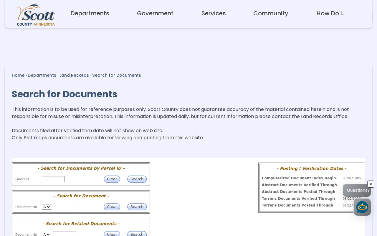
Use the notice to decide whether a recorder call, a Government Center visit, or a later recheck is needed before treating a missing document as a meaningful absence.
When a current PIN does not fit an older description, the RecordEASE tract index covers plats, metes-and-bounds descriptions, and condominium material. The county did not publish an exact online historical cutoff or digitization start in the sources inspected. Ask Land Records whether a paper book, microfilm, tract-index search, or in-person search is the appropriate next channel.
The tract-index page below illustrates the alternative legal-description route for a Shakopee street record.
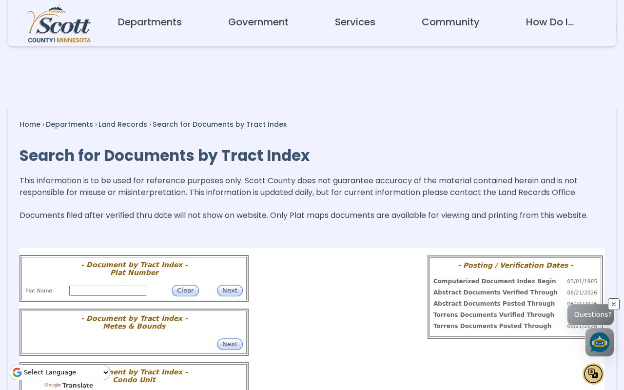
For plats or liens, the separate county search uses registered-land-survey numbers without spaces, with examples such as RLS004, rather than a street label alone.
Use Shakopee Street Permit Records
City-held address records add a different layer to a Shakopee street directory search. Shakopee Building Inspections directs many permit categories to the EnerGov public portal, including residential, plumbing, mechanical, sewer and water, fire-protection, demolition, tree, fence, and other work. The city says an account is required for the portal and describes card or e-check payment and review timing. That record is about an application or property work, not a statement about everyone at the address.
For maintenance, zoning, signage, and neighborhood issues, Code Enforcement's service-request channel relies on an account, address or PIN, and a short summary. Public results were not exposed in the research. Request a specific existing city record through the Shakopee information request form, giving the date range, department, address, and desired delivery method. The city says there is no inspection fee, although copy fees may apply.
Scott County also accepts public-data requests through its Data Request Portal and other documented channels, including electronic delivery, pickup, email, regular mail, fax, and on-site inspection. The county may estimate costs and request prepayment. This is the practical fallback for a record the portal does not expose.
Shakopee Street Records by Address
Several record sets can be searched by address or linked by the parcel number, but they do not answer the same question. Use the street directory as a source-and-date trail. The table separates land, map, recorder, municipal, and election channels so a reader can see what an address record actually shows and where the access boundary sits.
| Address-keyed record | Custodian | What it can show | Access route |
|---|---|---|---|
| Parcel and tax profile | Scott County Property & Taxation | Parcel fields, values, districts, and recorded-document links | Property Information website or county contact |
| Parcel and road mapping | Scott County GIS | Parcels, roads, imagery, districts, and spatial context | ScottGIS3, open data, or GIS office |
| Recorded land instruments | Scott County Land Records | Deeds, mortgages, releases, plats, and legal-description trail | RecordEASE subscription, recorder contact, or in-person path |
| Permit or code record | City of Shakopee | Dated municipal action connected to a property | EnerGov, service request, or City Clerk data request |
| Voter registration status | Minnesota Secretary of State and Scott County Elections | Individual confirmation only when required inputs match | MNVotes or the controlled statutory list-request route |
For an older address, pair the parcel trail with the Scott County Historical Society's plats, Sanborn maps, newspapers, census materials, church registers, cemetery maps, and card files. The historical collections are described more fully in the Shakopee Directory Book, where staff-assisted searches are especially useful when no city-directory run is confirmed online.
Read Shakopee Streets Through Plats
The Scott County Historical Society holds Shakopee plat maps from 1854, 1880, 1898, 1913, 1944, 1952, 1958, 1963, and 1974, along with smaller addition and neighborhood plats. Its Shakopee Sanborn Fire Insurance Maps date to 1884, 1890, 1895, 1902, 1910, and 1935. These sources help relate a lot, block, building footprint, or older street context to a modern parcel trail. They do not name every resident.
- Parcel
- A defined piece of land in the county property system, often identified by a nine-digit Property ID.
- Situs address
- The property location printed on a parcel record. It may differ from a mailing label or tax-geography field.
- Plat
- A recorded map that lays out lots, blocks, streets, and other land divisions in a subdivision or addition.
- Criss-cross directory
- An address-first directory format. No complete Shakopee run was confirmed in the research, so ask staff for a specific year and address.
Historical Society newspaper microfilm spans 1856 through 2014, and its current onsite page lists census material from 1857 through 1950. An older page stated a shorter census run, so confirm the shelf before a visit. Request the exact volume, year, page, or a statement that no matching item is held.
Keep Shakopee Street Geography Separate
A sample official parcel card demonstrates why one field should not overwrite another. It shows a Shakopee situs address with ZIP 55379, while its municipal and school fields display City of Prior Lake and Prior Lake school-district information. A street directory result should retain the street address, ZIP, tax municipality, school district, parcel geography, and record date as separate values. That prevents a valid tax label from being mistaken for a postal address or a current residence statement.
That distinction matters near municipal edges and in records that move between postal, taxing, and mapping systems. ScottGIS3 can supply parcel and district context, while Property Information supplies the selected parcel's profile. If the target becomes a wider ZIP question rather than a named street, use the Shakopee ZIP Codes reference to verify delivery geography before returning to parcel-level records.
Limits of a Shakopee Street Directory
Shakopee street records can document a parcel, a recorded transaction, a tax or municipal field, or an individual record role. They cannot turn those separate facts into a complete current-occupant list. A deed, tax parcel, permit, voter record, obituary, mailing address, or court caption each supports only the role and date stated by that source. A missing online result can reflect a verified-through lag, a subscription boundary, a non-digital record, or a privacy classification.
Minnesota's Government Data Practices Act access rules allow inspection and copies of public data while leaving confidential and private classifications intact. Safe at Home participants have special address protections. If a result displays a substitute address, do not try to connect it to a physical location through parcel or map records.
Lawful use. Use Shakopee address records for legitimate personal research and respect every portal limit, confidentiality rule, and protected location. Minn. Stat. §609.749 addresses stalking and harassment; public access never permits surveillance, threats, or unwanted contact.
Note: Verify a consequential address finding with the custodian and preserve the record date, source, and limits.